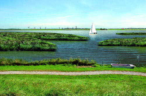
Wieringen is very old and was, up to 1930, an island. Wieringen Passage (Wieringerrandmeer) is situated in the north-west of the Netherlands.
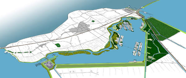
The design for the Wieringen Passage once again turns the former island of Wieringen into the sole boulder clay island of the Netherlands, with offshore sandbanks providing space for the development of recreational facilities and housing.
Recommended White Papers
Recommended Buyers Guides
The new Wieringen Passage connects the Amstelmeer with the IJsselmeer. Around 2,000 new permanent natural and recreational dwellings are planned in and around the passage.
The project involves development of 664ha of new natural areas and a new 850ha, 9km long lake on the border of Wieringen and Wieringermeer.
The Wieringen Passage is expected to provide much-needed economic impetus to the region. In addition, the project will enlarge and improve natural habitat areas and improve agriculture, recreation and rural living standards in the area.
The Wieringerrandmeer project is being developed as a public private partnership (PPP) involving the local authorities of Wieringermeer, Wieringen including the North Holland provincial authority and the designer companies.
Master Plan
Lago Wirense consortium was chosen for the design of the project through a competition held in 2003 by the municipalities and the province of North Holland.
The consortium, consisting of Volker Wessels Vastgoed, Boskalis and Witteveen+Bos, commissioned Strootman Landschapsarchitecten and Palmbout Urban Landscapes for the the master plan design. The basis for the development of master plan were many. The master plan for the Wieringen Passage was approved at the beginning of 2008.
Strootman Landschapsarchitecten and Palmbout Urban Landscapes won the first prize in the prestigious Leading European Architects Forum (LEAF) Award in September 2009 for the project’s master plan.
It was selected as the best European regional development project which includes protection of the area’s green space value development and its landscaping.
Wieringen Passage design
The Wieringen Passage design is on a regional scale. It involves simultaneous conceptualisation of a large body of water in the peninsula of Noord-Holland, traffic design around the lake, design of water edges and banks, the form of housing islands, subdivision principles and the design of bridges, housing thresholds and water levels.
The border lake is bounded by two distinctly different landscapes. The former island of Wieringen looks lovely with hills, narrow winding roads and typical elements. The scale Wieringermeerpolder is designed as a total concept and has a pragmatic device.
The border lake enhanced by the contrast in the design, links with both the civil characteristic of the Wieringermeerpolder, and the natural processes that the former island had formed.
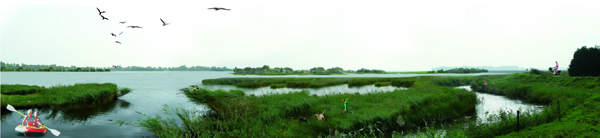
Ecological gradients are to be introduced depending on the depth of the water and the situation in relation to the island, ranging from the shallow foreshores to the reed lands just above water level, and from the wet grasslands to the dry-land wooded nature areas on the small islands with housing.
The configuration of the new islands is partly based on sightlines to and from Wieringen.
The shaped woodland elements play an important role in the visual structure of this part of the lake. They outline spaces, connect, hide or emphasise different parts of the area.
The atmosphere of the islands reflects the atmosphere of the land behind the dykes.
The western part the former island of Wieringen has a romantic, organically developed, soft-rolling landscape, while in the east there is the pragmatic polder of the robust Wieringermeer with its long strong lines.
In the eastern area the water is relatively deep and banks are steep. The easternmost island is like a boat floating in the lake. In the north-eastern part a new housing island is nestled against a relic of the former 'boezem' of the polder Waard-Nieuwland, which will dissolve in the future lake. Moreover, the historical dyke, the Wierdijk, which is now on the border between Wieringen and the polder can regain its traditional significance. Extensive areas for recreation and beaches will be scattered around the islands.
Space will be available for housing development on the eastern side of the lake with waterways for pleasure boats. On the southern shore, an ecological corridor, thin strip which will allow movement between two areas, will be created.
Environmental impact
By July 2009, the Environmental Impact Assessment (EIA) and the preliminary draft of inter municipal zoning of Wieringerrandmeer were ready. The EIA showed positive effects on the groundwater quality, natural values of the Waddenzee and IJsselmeer and possible bottlenecks.
Significant environmental effects such as water, nature, traffic, agriculture, landscape, cultural, tourism, external security and movement are well described in the EIA. The PPP is working on establishing a Land Exploitation for preparing the construction of the project. The preparatory work is expected to be completed by 2010 for the construction to begin.